GeoLibre v3.7.0

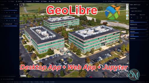
GeoLibre is a free and open source GIS platform built for visualizing, exploring, analyzing, and sharing geospatial data. What makes it especially interesting is its flexible approach to deployment. The same workspace can run in a web browser, as a desktop application, on mobile devices, and inside Jupyter notebooks. It also emphasizes local processing and privacy, making it an appealing alternative to heavier traditional GIS applications.

GeoLibre is aimed at users who work with maps and spatial data but do not necessarily want to install a large desktop GIS application. The browser version runs entirely client-side, with loaded data processed locally in the browser session. There is no required account or server backend for normal use.

Under the hood, GeoLibre combines MapLibre GL JS, DuckDB-WASM Spatial, deck.gl, React, TypeScript, and Tauri. This combination gives it a modern foundation for handling both traditional geospatial files and newer cloud-native formats.

Key Features of GeoLibre

Browser-Based GIS

GeoLibre can run directly in a modern browser without installation. Users can load supported vector and raster data, create maps, style layers, and perform spatial analysis without setting up a dedicated GIS workstation.

Desktop and Mobile Support

For workflows requiring filesystem access and native functionality, GeoLibre is also available as a desktop application for Windows, macOS, and Linux. The same project format can move between different versions of the application.

Cloud-Native Geospatial Data

One of GeoLibre's strongest areas is its support for modern cloud-native formats and services. It can work with GeoParquet, FlatGeobuf, PMTiles, COG, Zarr, vector tiles, GeoJSON, WMS, and other remote datasets.

This approach can be particularly useful when working with large datasets where downloading everything locally is unnecessary.

Spatial SQL

GeoLibre includes a SQL Workspace powered by DuckDB Spatial, allowing users to query and analyze spatial data using SQL. It also supports additional spatial engines, including PGlite with PostGIS and Apache Sedona.

Geoprocessing Tools

The application goes beyond simple map visualization. Its processing capabilities include vector analysis, raster processing, spectral indices, georeferencing, spatial statistics, network analysis, and conversion between geospatial formats.

3D and LiDAR

GeoLibre supports 3D Tiles, terrain visualization, and LiDAR datasets, making it useful for users working with 3D geographic information rather than only conventional 2D maps.

Plugin System

The platform includes a plugin API and plugin marketplace, allowing functionality to be extended without modifying the core application. This provides room for specialized workflows and third-party integrations.

Privacy-Focused Architecture

GeoLibre Web processes data locally in the browser and does not require an account or analytics for normal usage. Data only leaves the browser when users deliberately connect to remote resources or share a project.

Download GeoLibre v3.7.0 - Software Mirrors

GeoLibre v3.7.0 for Windows

GeoLibre.Desktop_3.7.0_x64_en-US.msi | 43.45 MB

GeoLibre.Desktop_3.7.0_x64-setup.exe | 42.43 MB

geolibre-desktop_windows_x64.exe | 47.5 MB

geolibre-desktop-3.7.0-x64.msix | 43.19 MB

geolibre-desktop-3.7.0-x64-portable.zip | 43.11 MB

geolibre-chrome-0.4.0.zip | 51.07 kB

GeoLibre v3.7.0 for macOS

GeoLibre.Desktop_3.7.0_x64.dmg | 45.44 MB

GeoLibre.Desktop_3.7.0_universal_mas.pkg | 113.23 MB

GeoLibre.Desktop_3.7.0_aarch64.dmg | 44.76 MB

geolibre-desktop_darwin_x64 | 48.6 MB

geolibre-desktop_darwin_aarch64 | 48 MB

GeoLibre v3.7.0 for Linux

GeoLibre.Desktop_3.7.0_amd64.deb | 44.28 MB

GeoLibre.Desktop_3.7.0_amd64.AppImage.zsync | 211.49 kB

GeoLibre.Desktop_3.7.0_amd64.AppImage | 120.68 MB

GeoLibre.Desktop-3.7.0-1.x86_64.rpm | 44.29 MB

geolibre-desktop_linux_x64 | 50.87 MB

GeoLibre v3.7.0 for Android

geolibre-android.aab | 174.66 MB

geolibre-android-x86_64.apk | 53.82 MB

geolibre-android-x86.apk | 53.89 MB

geolibre-android-arm64.apk | 52.72 MB

geolibre-android-arm.apk | 48.93 MB

GeoLibre v3.7.0 for iOS

GeoLibre_3.7.0_ios_app-store.ipa | 45.58 MB

Others Download related to GeoLibre v3.7.0

GeoLibre.Desktop_3.7.0_x64.app.tar.gz | 44.54 MB

GeoLibre.Desktop_3.7.0_aarch64.app.tar.gz | 43.86 MB

GeoLibre v3.7.0 Source Code

GeoLibre v3.7.0 Source code (zip)

GeoLibre v3.7.0 Source code (tar.gz)

GeoLibre v3.7.0 Release Notes:

GeoLibre v3.7.0 brings indoor maps, ArcGIS I3S Building Scene Layers, and JAXA Earth data. You can now open IMDF and IndoorGML buildings, step through their floors with an on-map floor picker, draw dashed and translucent lines, and lock a deployment down with new administrator switches. It brings together 48 pull requests from 6 contributors. Thank you to everyone who helped!

Highlights

  • Indoor maps: open an IMDF venue archive (the zip of GeoJSON that Apple Maps and many indoor tools export) as a ready-made 3D venue, or an OGC IndoorGML building from Add Data → IndoorGML Layer as extruded cells and its navigation network. An on-map Floor picker shows one floor, a cutaway of the floors below, or all of them, and clicking a room in the overview takes you to its floor. Try the Dinoseum and Berlin Hauptbahnhof samples. See Indoor maps.
  • Stacked floors from data: the extrusion base can now come from a field, a scale, or an expression, and a floor height stacks every floor of a building from its level attribute in a single layer. See Styling.
  • I3S and ArcGIS imagery: ArcGIS I3S scene layers draw again on deck.gl, and Building Scene Layers (BIM) load with discipline and category toggles. Hosted tiled imagery layers that cache raw LERC tiles, which used to come up empty, now draw through the ArcGIS SDK. See Adding data.
  • JAXA Earth: a new plugin under Plugins → Web Services browses all 119 JAXA Earth API datasets, from AW3D30 elevation to GSMaP precipitation and land surface temperature, and adds a band at a chosen date as a color-mapped layer you can step through in time. See Web Services.
  • Cartography and measurement: lines gain their own opacity, dashes, and blur in the layer style, also applied from imported Mapbox styles. The print layout gets a page background for dark maps and a footer that fits, and the field calculator, story maps, and processing tools measure distances and areas on the ellipsoid instead of a sphere. See Styling and Print Layout.
  • Deployment controls: administrators can turn off the Regional basemaps served from mainland China (an opened project that selects one now asks first), point the OSM Downloader at their own Overpass endpoint, save projects straight to the project server, open a plugin panel on startup, and give plugins a file-read allowlist. See Deployment Policy.
  • For plugins: data opened with ?data= or the embed addData command is offered to plugin file handlers, which can claim zips without an extension or declare their own dataType. See the Plugin API.
  • Fixes: COGs draw after opening a project with another basemap, Polygonize output draws containers before their islands, STAC searches send RFC 3339 date-times, an Ollama profile runs any typed model, spatial statistics find polygon neighbors from the area centroid, and the Android file picker keeps unmapped extensions selectable.

Download

Launch GeoLibre Web at https://web.geolibre.app, or get the desktop and mobile apps from https://geolibre.app/downloads/ (or the assets below).

What's Changed

  • chore(deps): bump the cargo-minor-patch group in /apps/geolibre-desktop/src-tauri with 4 updates by @dependabot[bot] in #3314
  • chore(deps): bump rusqlite from 0.40.2 to 0.41.1 in /apps/geolibre-desktop/src-tauri by @dependabot[bot] in #3315
  • chore(deps): bump the actions-minor-patch group with 2 updates by @dependabot[bot] in #3316
  • chore(deps): bump webdggrid from 1.11.0 to 2.0.0 by @dependabot[bot] in #3318
  • fix(processing): find polygon neighbors from the area centroid in spatial statistics by @GISspecialistAlejandraDuque in #3319
  • chore(deps): bump the npm-minor-patch group with 44 updates by @giswqs in #3322
  • feat(plugins): offer data loaded by URL to plugin file handlers by @GeraldJtB in #3321
  • chore(deps): regenerate the lockfile with npm 12 after the npm-minor-patch bump by @giswqs in #3324
  • fix(plugins): harden the zip entry listing for file handlers by @GeraldJtB in #3320
  • fix(android): keep unmapped extensions selectable in the file picker by @giswqs in #3326
  • test(e2e): scope the identify-restore Layers collapse click to the rail by @giswqs in #3327
  • feat: measure lengths, areas and processing distances on the ellipsoid by @GISspecialistAlejandraDuque in #3328
  • feat(plugins): add a JAXA Earth plugin under Web Services by @giswqs in #3329
  • fix(plugins): send writeFileToFolder data as raw bytes and add a subfolder option by @agraham9966 in #3331
  • fix(assistant): let an Ollama profile run any typed model by @giswqs in #3332
  • docs: start the docs sidebar sections collapsed by @giswqs in #3334
  • fix(stac): send RFC 3339 date-times in STAC search intervals by @giswqs in #3336
  • docs: add the NGIS 2026 full-day GeoLibre workshop by @giswqs in #3339
  • fix(zarr): stop the pick popup after its layer is removed by @giswqs in #3340
  • fix(raster): draw COGs after opening a project with another basemap by @giswqs in #3342
  • feat(vector): add a Berlin Hbf indoor sample dataset by @giswqs in #3345
  • feat(arcgis): draw tiled imagery layers with ImageryTileLayer by @giswqs in #3347
  • feat(style): data-driven extrusion base for stacking floors by @giswqs in #3344
  • fix(raster): draw Polygonize containers before their islands by @giswqs in #3352
  • feat(print-layout): page background, dark map panels and a footer that fits by @GISspecialistAlejandraDuque in #3349
  • feat(indoor): add an on-map floor picker for multi-floor layers by @giswqs in #3348
  • feat(indoor): import IMDF venue archives by @giswqs in #3353
  • fix(map): report the line paint a Mapbox style import cannot apply by @GISspecialistAlejandraDuque in #3343
  • feat(3d-tiles): draw I3S scene layers again and support Building Scene Layers by @giswqs in #3354
  • feat(indoor): click a room to go to its floor by @giswqs in #3356
  • docs: add an Indoor Maps and BIM guide by @giswqs in #3355
  • feat(indoor): import IndoorGML buildings by @giswqs in #3357
  • fix(3d-tiles): I3S review follow-ups by @giswqs in #3358
  • fix(map): turn simplestyle on when an imported style reads it by @giswqs in #3359
  • feat(style): line opacity, dashes and blur in the layer style by @giswqs in #3360
  • docs: add a generated Python API reference by @giswqs in #3362
  • docs: add JOSS paper and community health files by @giswqs in #3361
  • fix: address IndoorGML CRS state, I3S probe cache, and docs drift by @giswqs in #3363
  • feat(projects): add remote-first project storage deployment switch by @Hrushikesh-ramilla in #3306
  • feat(plugins): support openPanel in deployment policy (#2782) by @Hrushikesh-ramilla in #3307
  • feat(plugins): support fileAccess allowlist in deployment policy (#2782) by @Hrushikesh-ramilla in #3364
  • fix(deps): resolve npm audit advisories by @giswqs in #3366
  • fix(tiles): drop the maps.mail.ru Overpass fallback by @giswqs in #3367
  • feat(osm): allow a deployment-configured Overpass endpoint by @giswqs in #3368
  • docs: add a network endpoints page by @giswqs in #3369
  • docs: correct the nativeFetch address guard on the network endpoints page by @giswqs in #3371
  • feat(basemaps): confirm regional basemaps from opened projects and add a deployment switch by @giswqs in #3370
  • fix(i18n): translate leftover English values in 11 catalogs by @giswqs in #3372
  • chore(release): v3.7.0 by @giswqs in #3373
Full Changelog: v3.6.1...v3.7.0

Performance and User Experience

GeoLibre feels considerably lighter and more modern than many traditional GIS applications. The browser-first design makes it easy to open the application and start exploring data without spending time configuring a large desktop environment.

The use of DuckDB-WASM Spatial is particularly interesting for local analytical workloads, while MapLibre and deck.gl provide a modern foundation for rendering maps and 3D information.

The project is also developing quickly. The current stable release has expanded considerably beyond simple mapping, adding project files, plugins, processing tools, cloud integrations, 3D capabilities, and spatial SQL.

That rapid development is both a strength and a consideration. Users looking for the mature ecosystem and extensive tooling of established GIS software may still prefer QGIS for complex professional workflows.

Pros

  • Free and open source.

  • Runs in the browser, desktop, mobile, and Jupyter.

  • Local-first approach to data processing.

  • Modern cloud-native GIS support.

  • Powerful spatial SQL capabilities.

  • Supports raster, vector, 3D, and LiDAR data.

  • Extensive geoprocessing tools.

  • Plugin marketplace and API.

  • Modern and lightweight interface.

  • MIT licensed.

Cons

  • Still much younger than established GIS platforms.

  • Ecosystem is smaller than QGIS.

  • Some advanced GIS workflows may still require traditional desktop software.

  • Rapid development can mean features and interfaces change quickly.

  • Users unfamiliar with cloud-native geospatial formats may need some time to understand the workflow.

Who Should Use GeoLibre?

GeoLibre is a strong choice for GIS professionals, researchers, developers, students, data scientists, and organizations working with modern geospatial datasets.

It is particularly appealing if you want a GIS application that can work directly with cloud-native data, perform analysis locally, and remain accessible through a browser without requiring a traditional desktop installation.

Developers should also find the combination of TypeScript, React, DuckDB, MapLibre, deck.gl, and Tauri interesting for building customized geospatial workflows.

Final Verdict

GeoLibre is an impressive modern take on GIS software. Instead of trying to reproduce every feature of established desktop GIS applications, it focuses on browser-based workflows, local processing, cloud-native datasets, spatial SQL, modern visualization, and portability.

Its rapid development is perhaps its biggest advantage. The project has grown quickly from a lightweight mapping application into a much broader GIS platform with raster processing, LiDAR, 3D Tiles, spatial databases, plugins, and AI-assisted geospatial functionality.

It is not yet a complete replacement for QGIS in every professional workflow, but GeoLibre is already a compelling option for anyone interested in lightweight, private, and modern GIS software.
GeoLibre v3.7.0
Free
Software Informations:
Developer:

Operating System:
Windows / macOS / Linux / Android
Date Added:
2026-11-09T04:07:17.123Z
Categories:

Post a Comment/Report Broken Link: